Appendix – August, 1955 Southeastern PA Weather Highlights
Hurricane Diane Flooding and Specific Precipitation Data
The table below shows rainfall as measured at the Franklin Institute in Philadelphia in the 8 months preceding the arrival of Hurricanes Connie and Diane in the Delaware Valley. Precipitation is rounded to the nearest hundredth of an inch, and departure from averages (Differential) is rounded to the nearest whole percent. It should be noted that of all areas covered in Devastation on the Delaware, those locations south of Trenton, including Philadelphia, received the least rain. Therefore, this table isn’t intended to give an accurate picture of overall precipitation, it is mainly to establish the generally very dry conditions that existed before the flood; the worst drought the area had seen since the “Dust Bowl Days” of the 1930s.
[jtrt_tables id=”573″]
This information covers overall highlights of the weather that brought the flooding, and the flooding itself, over the three days that the Delaware River Valley was most impacted.
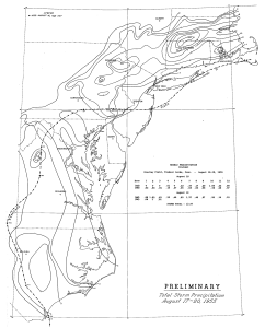 Weather Highlights – Aug. 18, 1955

- Hurricane Diane moved into the NC coast then recurved to the NE, passing very near Philadelphia, then to the Southern coast of New England.
- Diane’s heavy rains, up to 1″ in the Poconos, added to those of Connie 5 days earlier, brought massive flooding to the MidAtlantic and New England states during the next few days.
- Philadelphia received 0.16″ on the 16th, 0.44″ on the 17th, 2.32″ on the 18th and 0.06″ on the 19th, for a total of 2.98″.
- The storm killed between 184 to 200 people, making it onto the Deadliest Atlantic Tropical Cyclones, 1492 to Present, list. (At least 25 deaths needed to make this list).
Weather Highlights – Aug. 19, 1955
- Tropical Storm Diane brought torrential rain and flooding across the region.
- The S. Branch of the Raritan River at Stanton, Hunterdon Co., NJ, rose to a record 15.2′. Flood stage is 8.0′.
- The Bushkill River at Shoemakers, Monroe Co., PA, rose to a record 14.0′. Flood stage is 6.0′.
- The Brodhead Creek at Minisink Hills, Monroe Co., PA, rose to a record 27.0′, causing one of the worst disasters to hit the Poconos, killing more than 75 people (most at Analomink). Some bodies remained missing for years. Flood stage is 10.0′.
- The Delaware River rose to a record 37.4′, with flood stage 21.0′, at Tocks Island, Warren Co., NJ; a record 43.7′, with flood stage 22.0′, at Phillipsburg, Warren Co., NJ; a record 38.9′, with flood stage 22.0′, at Riegelsville, Warren Co., NJ; a record 27.8′, with flood stage 16.0′, at Frenchtown, Hunterdon Co., NJ; a record 28.4′, with flood stage 18.0′, at Stockton, Hunterdon Co., NJ; and a record 26.0′, with flood stage 13.0′, at New Hope, Bucks Co., PA. The Neshaminy Creek at Langhorne, Bucks Co., PA, rose to a record 22.8′. Flood stage is 9.0′. Sources: NWS Mt. Holly/Philadelphia; USGS
Weather Highlights – Aug. 20, 1955
- The Delaware River at Washington Crossing, Mercer Co., NJ, rose to a record 27.8′. Flood stage is 20.0′. (USGS)
A full 1956 report about Hurricane Diane and her floods is available online from the U.S. Geological Survey.
Source: Philadelphia/Mt. Holly National Weather Service